In this article I’ll explain what the GPX and KML files are that IÂ provide with many articles and how you can use them.
With most trail, road trip, and destination articles I provide two down-loadable files; a KML file, and a GPX file. Both files contain information about tracks, waypoints or both. A track is what you see on the map that accompanies the article showing the path I took. Waypoints are markers that show up on the map at specific locations.  While each of these files contains similar information, each has a particular use.
KML files are in a format that is compatible with Google Earth and Google Maps, as well as an increasing number of other applications. If you download the KML file from an article then you can open it using the Google Earth application and get a 3D view of it with satellite imagery. If you have not tried Google Earth, I highly recommend it. You can get a copy for free from Google!
The GPX files that I provide are actually compressed (zipped) versions of the GPX files. GPX stands for GPS Exchange. Once un-zipped, these files can be imported into many GPS units, particularly Garmin products. If you import the GPX file to your GPS unit then you should be able to see the track and waypoints that I captured as well as some additional information that I may have added later.
I should point out here that you can actually open GPX files with google earth as well. I include both types of files because sometimes I modify the KML file specifically for display within Earth.
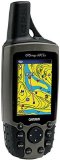
The GPS unit that I use most often is the Garmin 60CSx for several reasons. It uses AA batteries making it easy to use over extended periods of time when a charger may not be available. It’s memory can be expanded with a Micro-SD card allowing expanded map and track capture capabilities. For example, I have topo maps of most of the western US loaded on mine in addition to street maps. It also has a very sensitive receiver that seems to lock onto the GPS satellites faster than many other GPS units. One thing that I consider a feature, that some may not, is that it uses buttons rather than a touch screen for navigation, etc. This is a feature to me for two reasons… First, I’m often using the unit in dirty, dusty, gritty conditions and would be concerned that a touch screen would get scratched up quickly. Second, to protect the unit from bumps and dings, I keep the unit in a protective sheath which still allows the buttons to be pressed but would probably prevent a touch screen from working. This unit is also water resistant and includes both a barometric altimeter and a magnetic compass.
Thanks Joe. Recently started thinking about getting a GPS and this provides a good idea about what to look for. I have regularly used Big Trees Tech and provided my info a year or two ago but this is my first outgoing message. We have been working 5 yrs on the log cabin on Meko – first house on the left coming off 4. Finally nearing completion. Purchased the lot in 1971 from AFP when Meko was a dirt road. Now spending almost as much time here as our primary residence. Can’t thank you enough for the great service you provide.