Highs and Lows
History for
Elevation: | Latitude: | Longitude:
High/Low tables last updated via CumulusMX v: b:
Indoor data last updated
| Outdoor | Today | Yesterday | This Month | This Year | Since | |||||
| High Temperature | ||||||||||
| Low Temperature | ||||||||||
| High Dewpoint | ||||||||||
| Low Dewpoint | ||||||||||
| High Heat Index | ||||||||||
| Low Wind Chill | ||||||||||
| High Humidity | % | % | % | % | % | |||||
| Low Humidity | % | % | % | % | % | |||||
| Indoor | ||||||||||
| High Temperature | ||||||||||
| Low Temperature | ||||||||||
| High Humidity | % | % | % | % | % | |||||
| Low Humidity | % | % | % | % | % | |||||
| Pressure | ||||||||||
| High Barometer | ||||||||||
| Low Barometer | ||||||||||
| Wind | ||||||||||
| High Wind Gust | ||||||||||
| High Wind (10min avg) | ||||||||||
| Wind Run | ||||||||||
| Rain | ||||||||||
| Rain Total | since 1 | since Oct 1 | n/a | n/a | ||||||
| Daily Rain | ||||||||||
| High Rain Rate | /hr | /hr | /hr | /hr | /hr | |||||
NOAA Reports
About This Weather Station
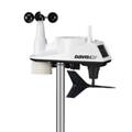
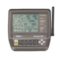 Weather data is collected from a Davis Instruments Vantage Vue weather station and a server running WeatherLink for PC as well as CumulusMX software. The exterior wireless sensor suite measures temperature, humidity, rainfall, wind speed and direction. The interior console measures barometric pressure as well as indoor temperature and humidity.
This station was established on July 6, 2012 in Dorrington, CA within Big Trees Village adjacent to Calaveras Big Trees State Park. Originally the console used a Davis 6555 IP data logger for connectivity. The 6555 logger was damaged in a lightning strike in January 2026 and replaced with a wifilogger 2 device. In addition to uploading weather information directly to this website, the station also sends data to the following weather sites:
From 2001 through April 2012, weather data was collected from a Radio Shack WX200 weather station running wx200d software. This station was retired in April 2012. Old historical graphs from this station are available here.